Compared on 30 September 2026

A Kurviger alternative

ArcRoute focuses on the ride itself, for iPhone riders from Britain to the Balkans: loops that land on the time you have, guidance that leads you on past a stop you missed, and a heatmap of every road you have ridden. All of it in English or Czech.

See it side by side
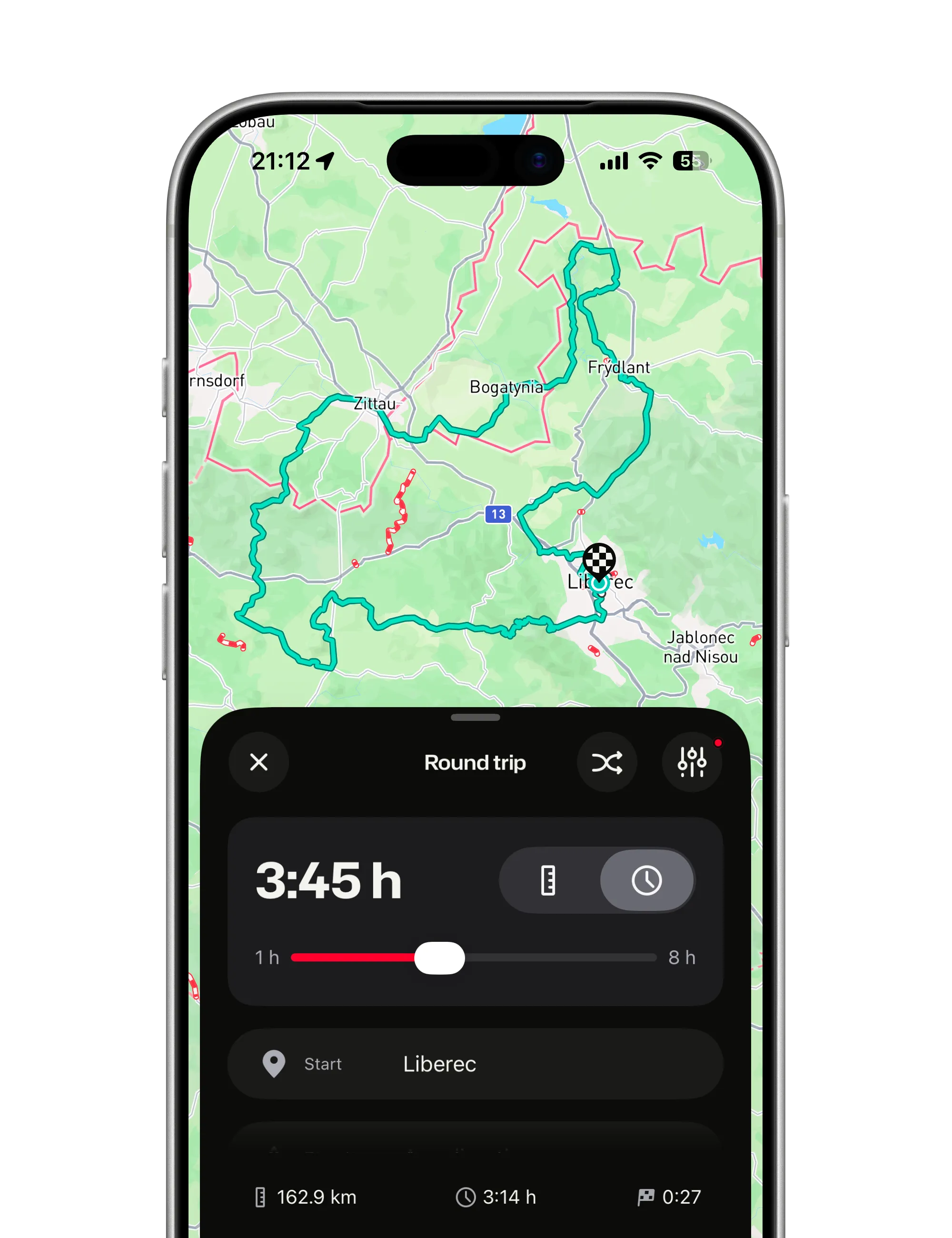
The round trip sheet set to 3:45 h from Liberec, and the loop it drew on the map through Zittau and Frýdlant

ArcRoute fits if you

  • ride with an iPhone in Britain, Ireland, the Benelux, France, Italy, Iberia, Morocco, Central Europe, the Alps or the Balkans
  • want a loop that lands on the time you have
  • want to ride on, not be sent back to a stop you missed
  • want a heatmap of the roads you ride most
  • want the app and the voice in your helmet in Czech
  • want one subscription with everything in it

Kurviger fits if you

  • ride with Android, or want the route on CarPlay or Android Auto
  • like to plan on a computer, or want to plan for free
  • ride outside Europe, or want offline maps on the phone
  • want to set the curviness section by section
  • want to send the route to a Garmin or TomTom device
Compare

Feature by feature

What each app does today, and what is free. Every Kurviger fact has its source under the table.

Feature by feature
FeatureArcRouteeverything in the subscriptionKurviger
Curvy routingYesfour steps, a riding time under eachYesfree and paidfour profiles; per section and side by side with Tourer
Round tripsYes50 to 400 km or 1 to 8 hoursYesfree and paidup to 300 km free, 600 km with Tourer
Voice guidanceYesEnglish and Czech, screen lockedYespaidwith Tourer+
Skipping stops you passedYeson its own, once a stop is behind youPartlypaidonly by hand in the navigation menu, with Tourer+
CzechYesapp, voice and websiteNosix languages, Czech not among them
Offline mapsPartlya saved ride runs without signal; no map downloadsYespaidmap downloads, with Tourer+
Ride recordingYesautomatic, with speed, elevation and estimated lean saved for a ride view to comeYespaidwith Tourer+
Ride heatmapYeshow often you rode each road, snapped to itNoa recorded ride opens as a route
GPX importYessnapped to roads, or the line as drawnYesITN and KML too
GPX exportNoYesfree and paidGPX, ITN and KML; more options with Tourer
Road closuresPartlyCzechia, official data, routed aroundYespaidshown and avoided when planning, with Tourer
CarPlay and Android AutoNoYespaidnavigation on both, with Tourer+
Android and a web plannerNoYesfreeweb planner free
Shared routes and group ridesNoPartlyroutes and folders shared between riders
Where it routesPartly27 countries, from Britain and Ireland to the Balkans, Iberia and MoroccoYesthe whole world

Written by the maker of ArcRouteFacts as of 30 September 2026

How it works

What ArcRoute does differently

Three things ArcRoute is built around. Each has its own page if you want more.

A loop that fits the afternoon

Say how far or how long, and which way. The loop comes back at or just under it.

  • Distance or time. 50 to 400 km, or one to eight hours.
  • Three hours stays three hours. ArcRoute measures the loop and asks again until it fits. Almost never four.
  • Curvy from the first turn. Balanced, Twisty or Wild, the same steps as a planned route.
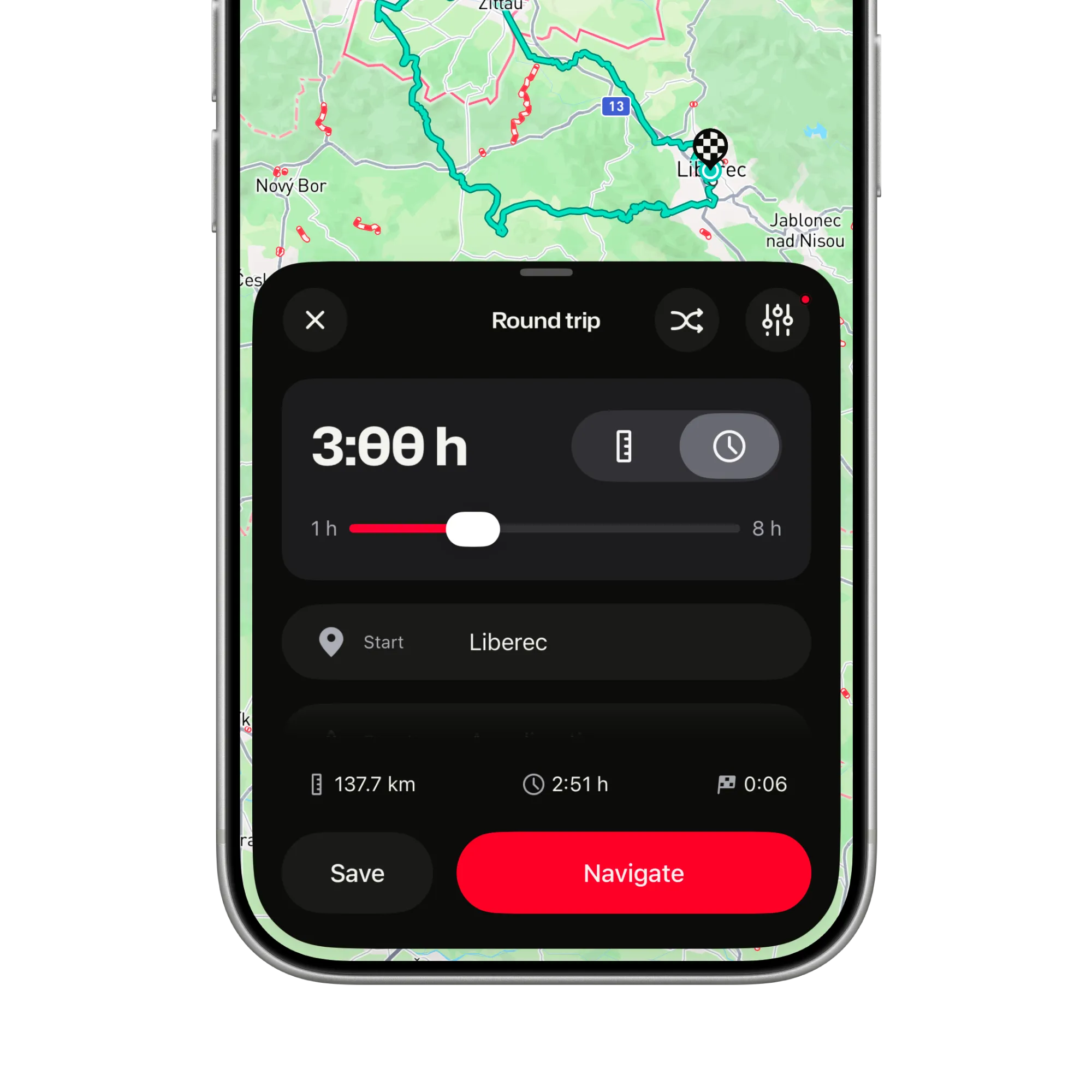
A round trip asked for 3:00 h: the loop from Liberec comes out at 2:51 h and 137.7 km, ready to save or navigate

Miss a stop and ride on

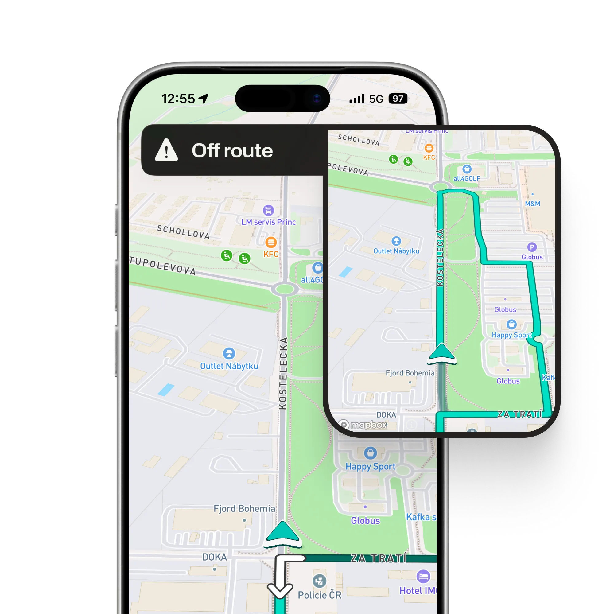
Leave the route and ArcRoute finds a new one from where you are pointed, on its own, with one calm spoken note.

  • Stops ahead are kept. Ones you have passed are skipped, not dragged back to.
  • Never against traffic. A reroute that would start the wrong way is thrown away and tried again.
  • In your helmet, in Czech or English. Screen locked, phone in your pocket.
An Off route banner over the map, and an inset of the new route leading on from where the bike points instead of turning back

Where you ride most, on one map

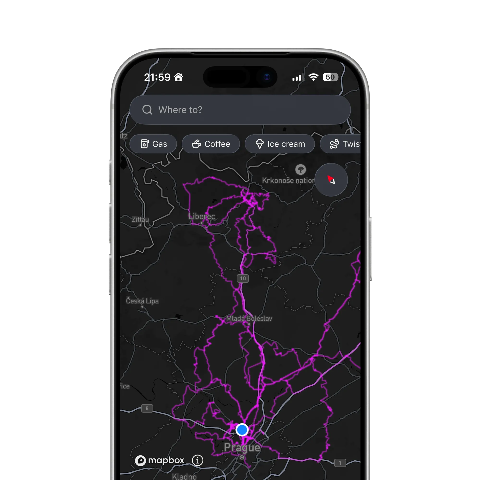
Record the season and watch your roads light up, brightest where you ride most.

  • Snapped to the road. Zoom in and every line follows its road, bend for bend.
  • Only rides you rode. Recorded rides count; imported files never do.
  • Ready without signal. Built on your phone from your own rides.
The map as it opens, in the dark style, with the heatmap reaching from Prague north to Liberec and the Krkonoše mountains

What it costs

The Kurviger prices are for Tourer+, its plan with navigation. Planning is free in Kurviger, and a cheaper plan, Tourer, adds planning extras. ArcRoute is one subscription with everything in it, and new riders try it free first. App Store prices, VAT included.

What it costs
PlanArcRouteKurviger
Free versionNonePlanning with ads, no navigation
Cheapest plan€6.99 a monthCZK 149 a month€6.99 a monthCZK 149 a month
A year€44.99CZK 999€29.99CZK 699
Free trial14 days7 days

Prices as of 30 September 2026

Try it on your own roads

Plan a loop, ride it, and watch it land on your map. Keep Kurviger while you decide.

Get the app
Switchbacks of a mountain road at dusk, seen from above
FAQ

Questions riders ask before switching

The support page has the rest, from sign-in to subscriptions.

All questions and support

Is ArcRoute free?

No. ArcRoute is one subscription with every feature in it, and new riders try it free first. The price table above has both apps side by side.

Can I bring my Kurviger routes?

Yes, as GPX files. Kurviger exports GPX; ArcRoute imports the file, snaps it to the roads and guides you along it with voice.

Is ArcRoute in Czech?

Yes. The app, the voice in your helmet and the website come in Czech and English. Kurviger’s app comes in six languages, and Czech is not one of them.

Does ArcRoute work without signal?

Partly. A saved ride runs from the phone, turns and voice included, but planning and rerouting need a connection, and the map shows only what the phone has already loaded. Downloadable offline maps are not there yet; Kurviger has them with Tourer+.

I ride with Android. What now?

Then Kurviger is the one to choose today. ArcRoute is built natively for iPhone, and there is no Android version planned right now.

Does ArcRoute work with CarPlay?

No. ArcRoute guides you with the phone on the bars or in your pocket and speaks into your helmet over Bluetooth, in English or Czech. Kurviger navigates on CarPlay and Android Auto with Tourer+.

Does ArcRoute route around road closures?

In Czechia, yes: ArcRoute reads the official closure data, plans around it and shows the closures on the map. Outside Czechia it does not know about closures. Kurviger shows current closures and can avoid them when planning, with Tourer.

Does ArcRoute send me back to a stop I missed?

No. Ride another way and once a stop is behind you, the recalculation skips it and leads you on. One you only just missed it still aims for, around the block if need be. In Kurviger you skip a waypoint by hand in the navigation menu.

Where does ArcRoute route?

In twenty-seven countries: Britain and Ireland, the Benelux, France and Italy, Spain, Portugal and Andorra, from Germany and Poland down to Albania, and Morocco. The coverage page shows each one with its roads. Kurviger routes worldwide.

Ready to ride?

  • Plan it.
  • Ride it.
  • Remember it.
Download on the App Store

Fourteen days free. Questions or feedback? Get in touch

© 2026 ArcRoute. Made by in Czechia.